Barely a trickle
- David Hill

- Jul 5, 2025
- 6 min read
Updated: Jul 9, 2025
Sat 5 Jul ‘25. DH, RW, PC, DL, JS, Scrumpy & Albus
With Glastonbury festival over for another year it was safe to head north to Shepton Mallet for todays walk, which would be an anti clockwise loop around a walk we last did way back in September 2021 . That was the week we will never forget, as Trevor had his little scare in Spain, when not a single one of us initially responded to his very muddled message. Coincidently hes back out there currently but hopefully enjoying a more successful and less costly holiday this week. With four from Wincanton and a car-less participant from Pitcombe being picked up on route, we all met at our usual starting point at the bottom of the old Fosse Way just after 0830. Although the forecast was for a mixed morning with a high chance of some precipitation, it was dry as we headed off, although the majority of us started the walk wearing out light waterproof jackets.

The last time we walked around in a clockwise direction, but to change it up a bit, and to potentially have the wind and rain behind us on the higher ground, we set of back up the road towards the traffic lights. In front of the old mill the lake level was not unsurprisingly well down with the dry banks all around very exposed, but at the top of the hill the higher lake still had a good quantity of water in it. We crossed the road and headed up Frog Lane, over the course of the old railway line and through Bullimore Farm yard.
Once into the fields the dogs were able to be let off as we started a steady climb towards the top of Whitestone Hill. There was a short overgrown area to negotiate before we arrived at the stone track which would take us along the ridgeline. Although the wind was blowing it was starting to get a bit warmer as we climbed with the views around us opening up more with every foot we ascended.

Right on top of the ridge a flock of sheep were using the shade under a lone tree to keep out of the ever increasing sunshine although as we looked further west we could see some threatening clouds and areas of rainfall, thankfully still a fair way off from us. The usual landmark of Glastonbury Tor was visible in the far distance whilst a bit closer to us the red and white marquees and other infrastructure could be seen all over the Worthy Farm site. It would certainly have been a different view were we here last Saturday as the 200,000 festival goers and their collection of tents and shelters would have been spread across the surrounding fields. We continued along the track and just before we were to pass through a gate, noticed a lone sheep in the hedge. On closer inspection it appeared to have its leg caught up in some loose fencing and it looked like it might also have it heads trapped in the orange and white nylon fencing. Deryck and myself decided we would attempt to free the young male and so entered the field, but the ram was not overly impressed to see us getting closer. He was still a youngster but had a small set of horns and so we approached very carefully. We managed to grab hold of the trapped leg but just could not untangle the netting, and with no chance of getting it free from around his neck, we decided to leave it alone and get it reported to someone as quickly as possible.
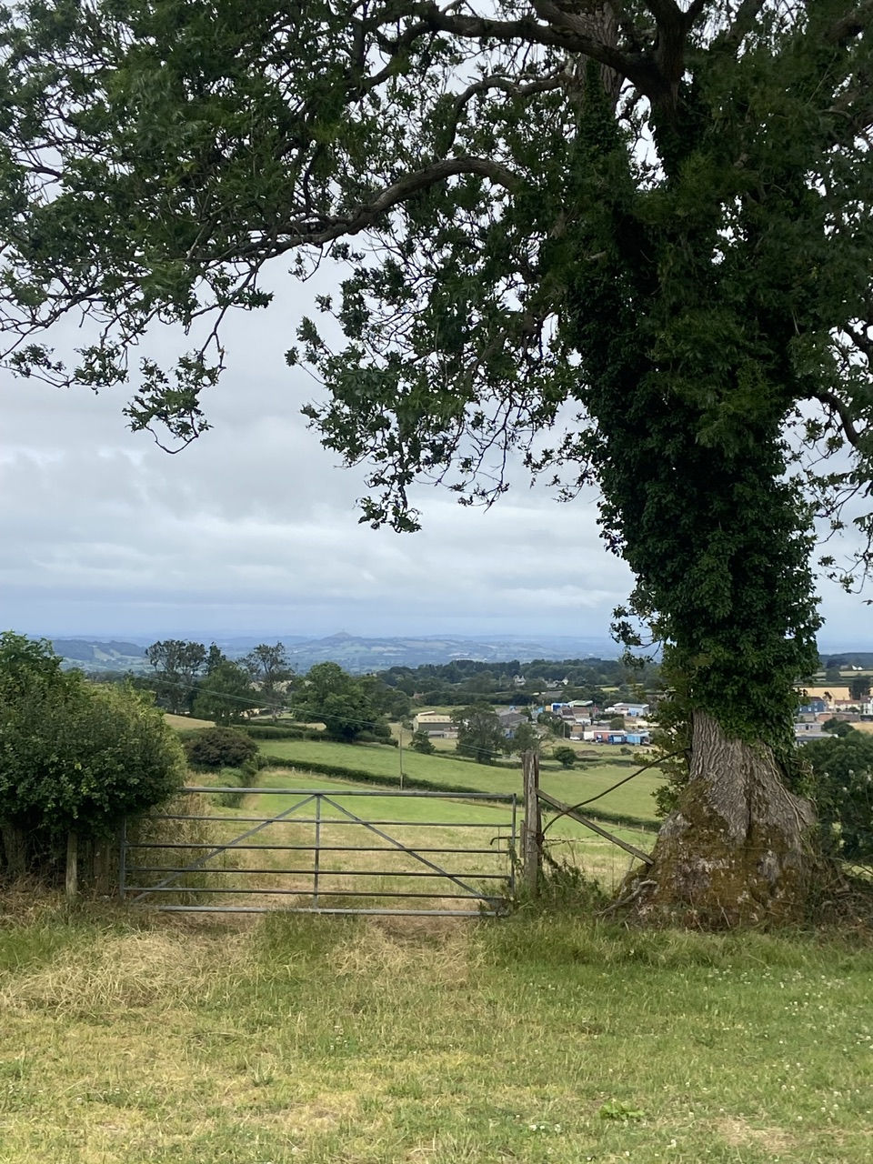
It was not obvious which farm the sheep might be from so knowing that there was one at the end of the track we pushed on hoping that we would find someone there who might know who the sheep farmer was be able to pass on the message. There were almost 360 degree views from the ridge across much of the area we walk on Saturday mornings, from the highs of Creech Hill to Alfred’s tower and surrounding woods to the south east and Cranmore tower to the north. The wind was blowing us along past the highest point of the day at 215 metres, (almost 20 metres higher than Creech Hill) which was marked by the concrete triangulation pillar. Unfortunately this trig pillar would now be pretty unusable for surveying purposes as it has been surrounded by a number of young apple trees which would restrict any views through a theodolite sat on top of it.
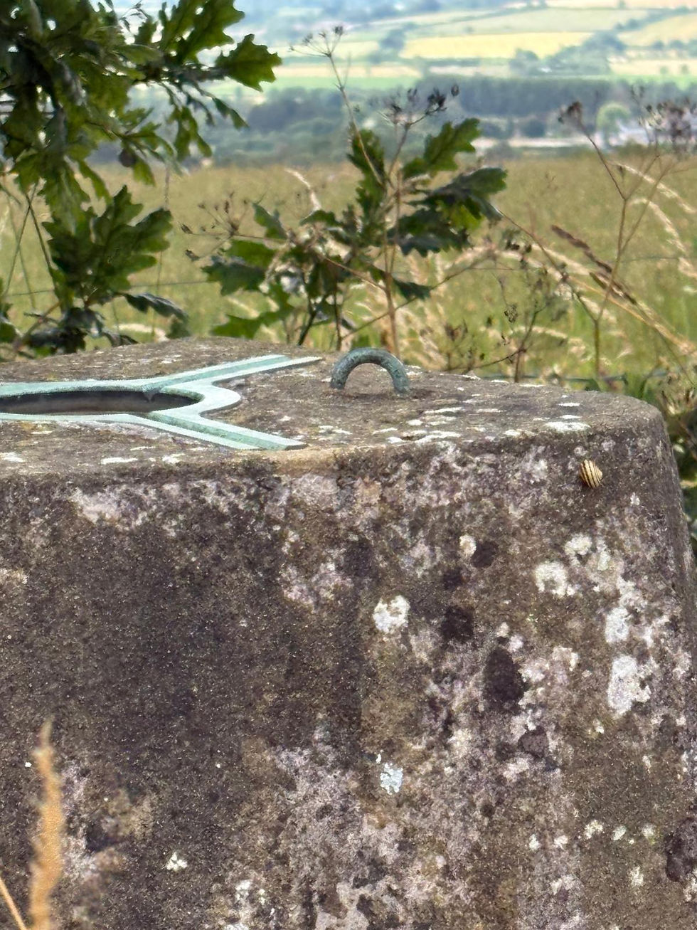
For those interested, there were 6,190 trig pillars built across the country by the Ordnance Survey and used for the initial triangulation of the British Isles between April 18, 1936, and June 4, 1962. With the advent of GPS many have actually been removed from the middle of fields or other areas where they are no longer required. The very first trig pillar was installed on April 18, 1936, in Cold Ashby, Northamptonshire, the highest is on top of Ben Nevis and the lowest is actually at -0.5 metres on the Cambridgeshire fens.
As the group split along the top, I pushed ahead to Whote Sleight Farm where I managed to find the owner tending her garden and informed of the sheep’s predicament. She immediately said she would contact the farmer concerned and so by the time we all regrouped, I was able to pass on the good news. As we climbed a gate by the arm we noticed at least three red kites flying low over the small valley to the north, the first we have seen for a few months.

At the end of the track we turned left onto a road towards Doulting, which took us over the last section of line operated by the East Somerset Railway as it drops down towards the end of the line at Mendip Vale station. As we approached Doulting we passed the rather splendid 15th Century Manor Farm Tithe Barn, a grade 1 listed property. Crossing the busy A361 we then headed round the back of the village for the first time, past the original village well head and down school lane with the lovely Old Bell House being the last property before we dropped downhill to arrive at St Aldhelms Well.
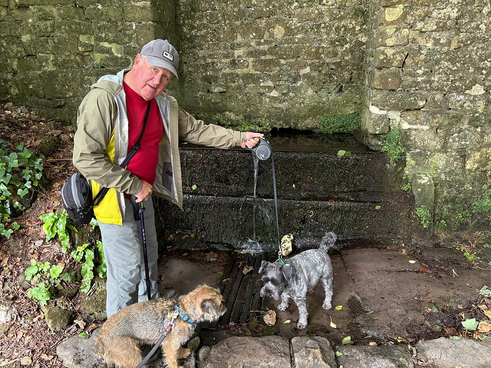
There was barely a trickle coming through the wall today but Albus and Scrumpy both managed to get a drink from the spiritual waters and recognised source of the River Sheppey. We moved on further down the track past the old pump room, which used to pump the water up to the street water supply we passed earlier, was also bone dry. We then came across a slight diversion to the path, (presumably due to a damaged bridge), which took us right next to some of the ponds, although they certainly didn’t look too inviting today. We were now on the final leg back across multiple stiles and through fields of cows and waist high maize and literally with about 10 minutes left got hit by a sudden squall. Thankfully it didn’t come on too heavy although by the time we got back to the cars we were all pretty damp.
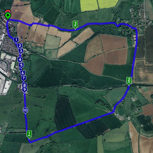
we had completed todays 3.6 miles in 1 hr 44 minutes, which allowed us just enough time to get out of our wet coats and boots and take the 5 minute drive into town, for breakfast at the Brasserie at the top end of the High Street, where we arrived spot on our booked time of 1030. It did help by getting a parking spot right outside of the front door. Deryck took a slight detour to the bakery whilst we went to our table. The choice was good today and once paid for at the counter the drinks were served very quickly, in some nice big tea pots and China cups and saucers.
Three of us opted for the lighter scrabble egg option and there were two full English breakfasts. The waitress even brought out some dog treats, which Scrumpy kept to herself, so any memories of our previous visit, when a young Maisie left her mark, is obviously water under the bridge by now.
Comments