All white at Westbury
- David Hill

- Sep 27, 2025
- 6 min read
Updated: Oct 1, 2025
Sat 27 Sep ‘25. DH, DL, CH, JS & Albus
We’ve always had a unwritten rule of a 30 minute travel time which gives us a high area, but occasionally it’s worth pushing the boundaries a little bit to have a walk in a different area. With just the same four from Wincanton as walked around Kington Magna a couple of weeks ago, it was a quick drive up the A303 and A350 to Westbury, less than fourty minutes from door to RV at the top of Westbury Hill. I have previously walked a similar route with a friend but starting at the bottom in Bratton, but he was not available to join us today so I opted for the shorter drive to the RV and a down and up today.

There was a cool wind blowing as we exited the car I was glad I wasn’t wearing shorts today as John was. It was definitely a case of coats all round, with the addition of a woolly hat and gloves for Chris. We passed through a gateway and down to a stone on which a panorama had been installed by the local primary school, when some of us were still in school ourselves. The view to the north today was not that clear as a light haze restricted visibility to a couple of miles. We could see the town of Westbury to our left and in front of us the now chimneyless remains of the infamous Westbury cement factory. Around to our right the feint outline of the hills beyond Devizes leading to the Vale of Pewsey. And of course in the foreground the immaculate white horse initially carved into the hillside around 300 years ago, which we just had to use as the background for this weeks groupie.

We followed a well worn track around the top of the ridge and past a few harness or abseiling points along the edge, no doubt used by whoever temporarily defaced the horse a couple of weeks ago with a red material St Georgss cross. We stopped for more photos at the tip of the horses ear and it was clear then how the surface has been covered in a white concrete which makes the shape stand out for miles around. The figure looked totally distorted from this angle and the black eye far bigger that it seems from a distance. Albus was ‘encouraged’ to pose for his photo on the tip of the ear, but didn’t look overly keen on the idea.


Behind the horse stands the hilltop earthwork defences of the Iron Age fort of Bratton Camp constructed over 2,000 years ago. The earthworks protected a settlement, containing round houses, granaries, stores and workshops. The double banks and ditches may have symbolised the dominance and power of the hillfort community and would have been formidable obstacles to enemies. Excavations within the fort in the 18th century by Jeffrey Whitaker, a local schoolmaster, uncovered quern stones, pottery, and Roman and Saxon coins. The whole area is now designated as a SSSI. We continued around the edge of the hilltop and joined a minor road rising up from the village of Bratton which was one of the original entrances into the camp.

We took a small path off to the right and continued downhill before arriving at a small crossroad. We could have taken the road to our right to start the return climb but I was curious to discover what the small footpath was like leading to the church in the bottom. The path continued along the side of a garden before dropping down a long flight of stone steps to a small bridge and then up a similar flight on the other side. At the top of the flight of shallow but regularly spaced steps we came to the gates to The church of St. James the Great.is set on the edge of the village in a combe on the site of the ancient medieval village of Little Stoke. This hamlet, which lay in the combe near the church, disappeared over 350 years ago. Local tradition says that the houses became ruinous after most of the inhabitants had died of the plague, but no documentary evidence of such a fate has been found.

We entered through the gate to see this small but striking listed building of Saxon origins. Some of the trees that surround the church were planted in 1829, but it was not until 1832 that a road was built to the church. The Rev. Charles Palairet made many improvements in the mid 19th century, one of which was the building of the 208 steps, rising from near the steam of Salcombe Water to the church, up which we previously walked. Inside the church are two benches removed from the church at Imber when that village was taken over by the Army for military training.
We headed back out through the gate and around the side of the churchyard and came out at the bottom of the aforementioned Coombe. Old deciduous trees formed the left edge of a pathway leading diagonally up the southern side of the dry valley. Dereyk remarked that it reminded him of other areas of the country including Derbyshire and Dartmoor.

The climb was slow and steady with multiple stops to admire the scenery, both of the wide Coombe and of the edges of Salisbury Plain as it moved from one valley to the next heading eastwards. Albus was initially on the lead as there were sheep in the field but once it was seen they were separated by a fence he was off and running. If only we all had lfour by four by paw” to get us up the hills! The sky was starting to clear and it was certainly getting a lot warmer and so as we reached the top the cool southerly breeze was very welcome indeed. We followed the top fence along to a gate and the turned left through a sunken lane in the chalk to reach the Imber Range Perimeter Path, a wide track which marks the edge of the military training area.

At over 94,000 acres, Salisbury Plain Training Area (SPTA) is the UK’s largest training area. It offers live firing and other facilities for armoured vehicles, artillery, engineers, infantry and aircraft. The regular Army, Army reserves and cadets use the training area, as do our NATO allies. Salisbury Plain Training Area (SPTA) is the same size as the Isle of Wight, covering a ninth of the county of Wiltshire. It spans from Warminster and Westbury in the west, to Tidworth and Perham Down in the east. The village of Imber, evacuated in 1943, remains uninhabited, but one service a year is still held in the church, which is well fenced and protected. The use of Salisbury Plain as a military training area has preserved a substantial archaeological landscape dating back some 6,000 years. There are about 2,300 monuments, 550 of which are protected by law. The Plain also has one of the densest concentrations of ancient long and round barrows anywhere in Britain.

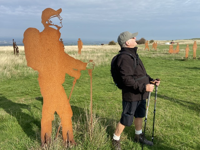
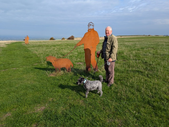
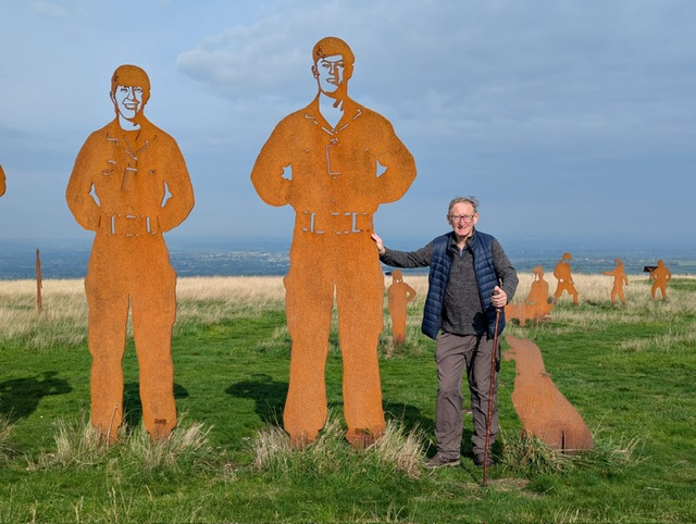
As we walked along the track which also forms part of the White Horse trail and the Wessex Ridgeway (which connects Marlborough to Lyme Regis) small arms could be heard firing somewhere on the range area. It didn’t sound controlled enough to be target shooting so I can only guess that it was an exercise possibly with cadets, who were carrying out a section attack. It went on for a few minutes and Albus was not too impressed with the noise. We left the track at a group of dilapidated farm barns and headed across open ground to an art installation of sheet metal figures. Standing proud over the rolling Wiltshire hillside, the installation features 10ft-high silhouette ‘giants’ modelled on soldiers from 5 Rifles - which conducts military training on nearby Salisbury Plain – alongside figures representing members of the public. Designed by the Standing With Giants charity, the artwork is to raise awareness of the MOD’s Respect The Range campaign.

There we quite a few of the figures which looked like they might have been modelled on members of the ‘walking dead’, so at the end are some of the photos, but I will leave you all to work out who’s who! We completed the walk back at the cars having covered just over three miles in around 100 minutes, with over 125 metres of climb. It was then a ten minute drive back down the hill and into Westbury to grab a bite to eat. I managed to grab a parking space in the pedestrian area of the high street, almost opposite the White Horse cafe. Taking the last table for four we all selected the ‘Breakfast 2’, with two bacon, two sausage and the usual other bits. The ‘breakfast 4’ was definitely for the hungrier ones. Service was pretty good and the breakfast above average for the price. All in all it was worth the extra few minutes drive to go somewhere outside of our normal boundaries.


Comments